

Ron Rattray
The following is an aftershock of yesterdays offshore quake in Northern California. It is the strongest one so far and may signal a swarm.
Region: OFFSHORE NORTHERN CALIFORNIA
Geographic coordinates: 40.318N, 124.591W
Magnitude: 4.3
Depth: 16 km
Universal Time (UTC): 29 Jan 2015 19:13:55
Time near the Epicenter: 29 Jan 2015 11:13:55
Local standard time in your area: 29 Jan 2015 11:13:55
Location with respect to nearby cities:
39 km (24 mi) SW of Ferndale, California
48 km (30 mi) SW of Fortuna, California
64 km (40 mi) SW of Eureka, California
73 km (45 mi) SW of Bayside, California
328 km (203 mi) NW of Sacramento, California

BobShannon
SOUTHERN CORONAL HOLE: A
vast hole has opened in the sun's atmosphere over the sun's south pole.
The gap, also known as a 'coronal hole', is colored cobalt blue in this
extreme UV image of the sun from NASA's Solar Dynamics Observatory:


Fire Photo by Bob Shannon
I heard a fire call come in on my scanner. They announced it was in Cheney but I didn't recognize the roads so got out my mapping system which is still on paper. I found the location which is most certainly 15 miles East of the Cheney city border. It is closer to Spokane's S Hill than Cheney. I suspect they do this for logistical reasons including any air support they might need.
I went up to EWU and climbed the big hill up at the water tower. It may have been signed as no trespassing however if so it was done poorly. I pointed the longest lens towards the smoke which you can see rising. The fire ended up being in a few old perhaps some rare cars but lay rusting in someones back yard. It was doused quickly. This was prior to Guillain Barre.
I went up to EWU and climbed the big hill up at the water tower. It may have been signed as no trespassing however if so it was done poorly. I pointed the longest lens towards the smoke which you can see rising. The fire ended up being in a few old perhaps some rare cars but lay rusting in someones back yard. It was doused quickly. This was prior to Guillain Barre.

Columbia Plateau Rail Trail
M3.6 - 12km ENE of Anthony, Kansas
Event Time
- 2015-01-29 20:21:38 (UTC)
- 2015-01-29 12:21:38 (UTC-08:00) in your timezone
Most of North America east of the Rocky Mountains has infrequent earthquakes. Here and there earthquakes are more numerous, for example in the New Madrid seismic zone centered on southeastern Missouri, in the Charlevoix-Kamouraska seismic zone of eastern Quebec, in New England, in the New York - Philadelphia - Wilmington urban corridor, and elsewhere. However, most of the enormous region from the Rockies to the Atlantic can go years without an earthquake large enough to be felt, and several U.S. states have never reported a damaging earthquake.
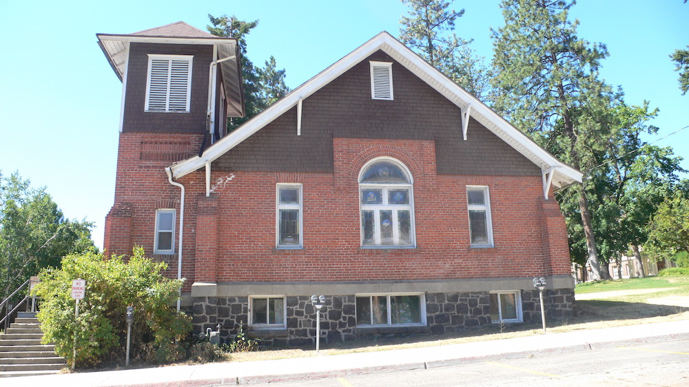
A very old church in Cheney, WA. Open to correction I believe it is the United Methodist Church.
STATE FORECAST FOR EASTERN WASHINGTON-
500 AM PST THU JAN 29 2015
..DENSE FOG ADVISORY IN EFFECT UNTIL 10 AM PST THIS MORNING FOR KITTITAS VALLEY... TODAY...MOSTLY CLOUDY. AREAS OF FOG WITH PATCHY MORNING DRIZZLE. HIGHS IN THE MID 30S TO LOWER 40S.
TONIGHT...MOSTLY CLOUDY. PATCHY FOG. LOWS AROUND 30.
FRIDAY...MOSTLY CLOUDY. PATCHY FOG. HIGHS IN THE MID 30S TO LOWER 40S.
SATURDAY...MOSTLY CLOUDY. AREAS OF FOG. A SLIGHT CHANCE OF DRIZZLE. HIGHS IN THE MID 30S TO LOWER 40S. LOWS AROUND 30.
SUNDAY...CLOUDY. PATCHY FOG. A CHANCE OF RAIN OR SNOW. HIGHS IN THE MID 30S TO LOWER 40S. LOWS IN THE LOWER 30S.
MONDAY...MOSTLY CLOUDY. A CHANCE OF RAIN OR SNOW. HIGHS IN THE MID 30S TO UPPER 40S. LOWS IN THE 30S.

This is from good friend and Pinpoint group member Stephen who has a large seismograph in his home. It is the same as the USGS uses. Stephen is part of the Pacific Seismic Network. The gif is a trace of yesterdays quake 5.6 a few miles from Ferndale but as it was a subduction quake, it did relatively no damage and was short rocking motion with no bang prior.
No comments:
Post a Comment